


Tornado Alley — the region of the U.S. that sees tornadoes and severe weather more frequently — has shifted into southern Illinois as favorable weather for tornadoes has increased significantly in areas farther east, causing meteorologists to believe the alley is shifting.
For decades, Tornado Alley was centered in the Great Plains, spanning from South Dakota and reaching parts of Colorado, New Mexico and Texas. The trend of tornadoes forming more frequently east of Tornado Alley had been studied since the early ‘90s. The change was made official in 2024.
Advertisement
Tornadoes are not uncommon in the U.S. On average there are about 1,200 tornadoes a year, according to National Geographic with around 71 deaths a year on average, according to CBS News. This also comes with the loss and damage of property at about $5.4 million per year, according to IOP Science, a website from the Institute of Physics that provides journals and archives from scientific studies and physics.
The shift to southern Illinois
States including Illinois, Mississippi, Alabama, Arkansas, Tennessee, Kentucky and Indiana have seen an increase in severe weather within recent decades. Meteorologists noticed this change in 2023, when severe storm outbreaks and tornados swept across the midwest in late March and early April.
Advertisement*
This led to a study called the Verification of the Origins of Rotation in Tornadoes Experiment or VORTEX project at the City University of New York, in collaboration with the National Severe Storms Laboratory, which eventually concluded that Tornado Alley has shifted east into southern Illinois. Data from the VORTEX project shows a direct correlation between population density of the Midwest and the formation of more frequent tornadoes near moisture-rich areas along the Mississippi and Ohio rivers.
The new tornado trend shows a direct correlation between severe weather and the effects of La Niña patterns. This pattern begins in the Pacific Ocean, where temperatures can become colder than normal. La Niña changes the path of the jet stream, which is a fast, narrow current of air that flows from west to east high in the atmosphere, which is a key to global weather. This allows the warmer air from the Gulf of Mexico to move north, while the cold air pushes down.
When the warm and cold air meet, it causes favorable conditions in the atmosphere fueling strong storms to hit the states. This is why areas outside of the original Tornado Alley, like southern Illinois, are seeing stronger storms and more frequent tornadoes, according to VORTEX project research.
Tornado and severe storm safety
Jordan Levinson, a firefighter and paramedic who was a member of an ambulance task force that responded to the Joplin, Missouri Tornado in 2011, shared his big safety tips for severe weather and how to prepare for it.
Firstly, Levinson said, get indoors, into the lowest level of a structure. The Federal Emergency Management Agency suggests if you do not have a basement, find a room in your home without windows in the middle of the house. Levinson said to get down to your hands and knees along the wall and try to cover your head and neck with your hands. FEMA has also suggested helmets for children in tornado conditions.
Levinson recommended having emergency supplies on hand before severe weather is expected to start. Emergency supplies include nonperishable food, bottled water, matches, candles, a portable radio and extra batteries.
“Have your phone with you but understand that there is a good chance the towers have been damaged so service might be down,” Levinson said.
In case your phone does not have a connection, he said that a portable radio that receives emergency signals and hand-cranked radios would be useful.
Christine Wielgos, a warning coordination meteorologist at the National Weather Service in Paducah, Kentucky, said people need to have multiple ways to access warnings. Wielgos’ main job is to connect weather science with the public and emergency decision-makers.
“You are supposed to be acting on these things, and the people that survive major tornadoes take shelter,” Wielgos said.
Wielgos also said to check in on loved ones, making sure they have an action plan and are aware when severe threats occur. If you wake up and know there is a severe weather threat, be sure and alter potential plans, and figure out where your loved ones are, she said.
Wielgos said that if you have pets, make sure you have an action plan, and find their carriers. FEMA recommends that you have pet supplies, including animal food, leashes, carries and any medication, included in your emergency plan along with microchipping pets.
Talking with experts
Wielgos, who has studied the shift of Tornado Valley, said she believes that southern Illinois has always been in the path of severe weather.
“In the mid- to late ‘90s, we barely had 20 tornadoes a year,” she said. “As time went on, the numbers went on a rollercoaster ride… How many people in the 2000s had cell phones? Now we take pictures of everything, and report everything, with a new world to report things with social media.”
Because of the technology shift in the past decade, tornadoes have been easier to report and document.
“Certain years we have more tornadoes in different parts of the country than other years. Based on the patterns, based on the atmospheric conditions that happen to be in play in that particular year that allows us to have tornadoes,” Wielgos said.
She also said that tornadoes have a season where they are more likely, but you should be prepared all year round for severe conditions.
“Tornadoes are possible all year round, around the clock, there is really no time we can’t have tornadoes,” Wielgos said.
Weather in southern Illinois
Even with the new shift in Tornado Alley, southern Illinois is not unfamiliar with strong storms, tornadoes, or even derechos. Derechos are sometimes referred to as “inland hurricanes” because they can cause hurricane-force winds in landlocked areas. They are strong storms, fueled by humid and hot weather. They move faster than other storms, and they also come with an “eye,” as hurricanes usually do.
In 2009, a derecho hit southern Illinois. The storm, often referred to as the “May 8 Storm,” hit the region with 90 mph winds and brought several tornadoes with it.
“That was a once-in-a-lifetime thing, or at least a once in a year thing for me,” Wielgos said. “That complex of storms actually started way out in the plains. That was 90-100 mile winds across part of Southern Illinois with some brief tornadoes mixed in there. It was a hot mess.”
Jessica Whittaker, a native of Galatia, Illinois, watched the storm while at work in Herrin.
“There was talk of an upcoming ‘inland hurricane’ for days. What did that even mean? A storm? Lots of wind? Nobody actually knew what to expect and figured it was just media hype anyway,” Whittaker said.
Several National Weather Service meteorologists considered the 2009 storm to be one of the worst derechos in the past decade. The Storm Prediction Center issued two “particularly dangerous situation” severe thunderstorm watches across the Plains and Midwest.
Whittaker recalls trees almost lying flat in the high winds and debris was flying everywhere outside.
“It had rained for days before so the ground was saturated; most mature trees just couldn’t hold up their canopies and laid over. It was wild. Roofs blew off houses, flimsy structures blew away. Most roads were closed due to debris of some sort,” Whittaker said.
Whittaker said that in the town of Galatia, several community members came together to help one another with the aftermath of the derecho. Community members and neighbors that had generators were helping houses without power, plugging in refrigerators.
“If you had a saw, you were cutting. If you didn’t have a saw, you were dragging debris.” Whittaker said.
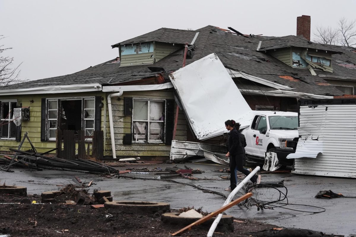
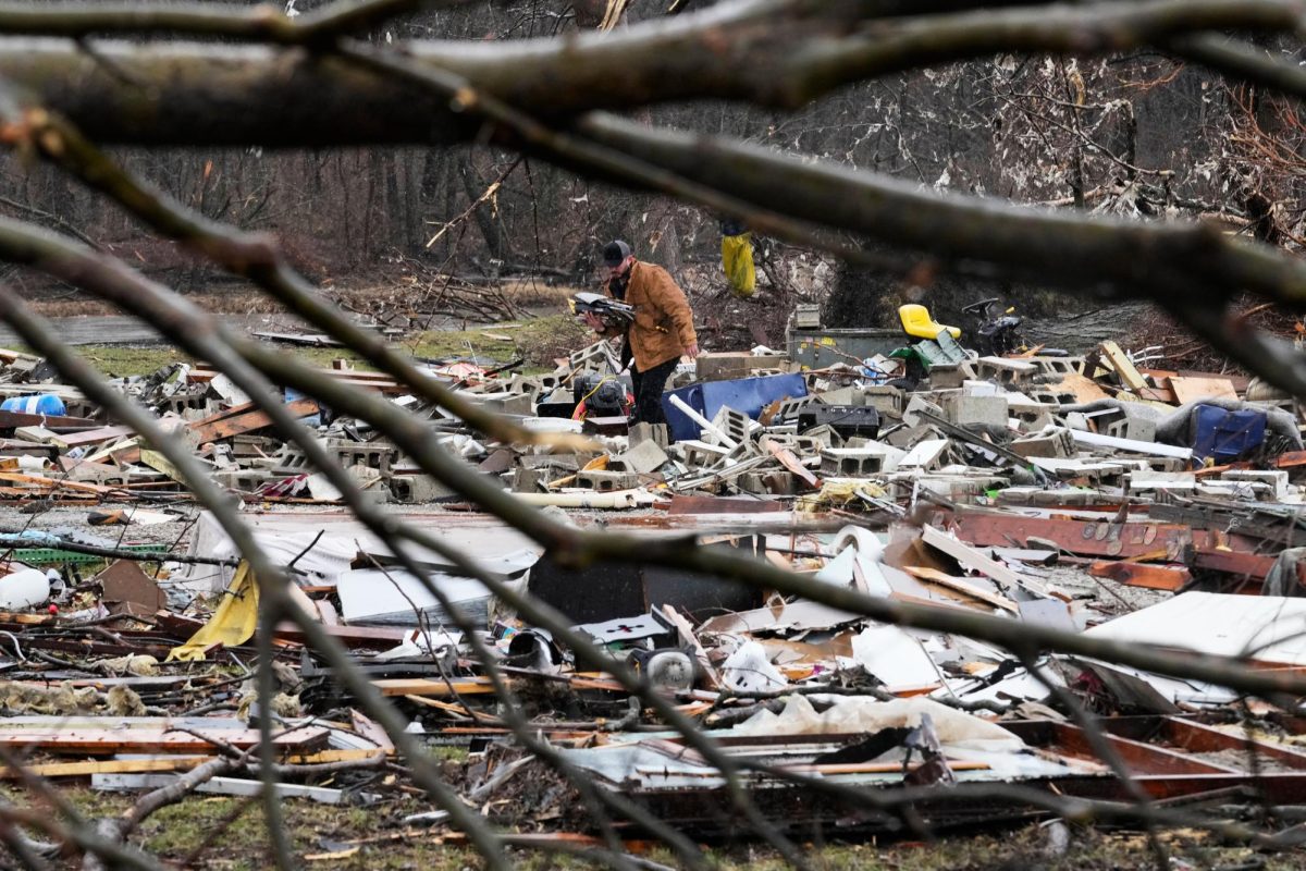
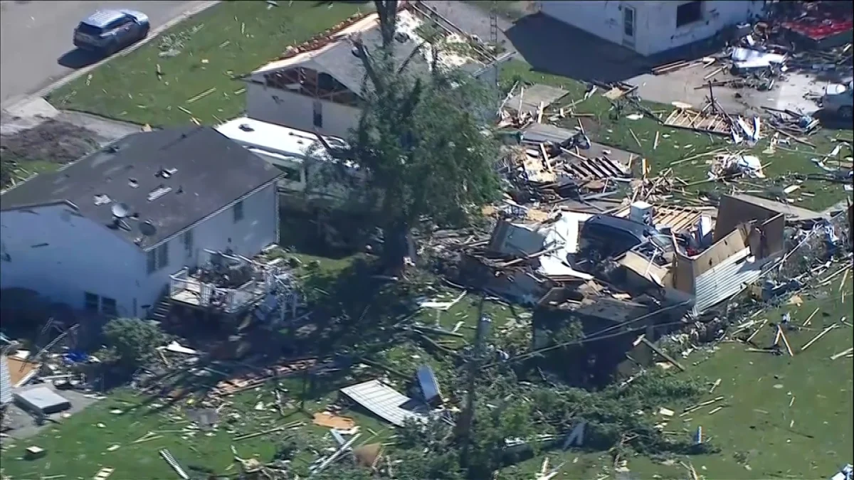
Southern Illinois has seen strong storms since then within recent years. On March 13 and 14 of 2025, a low pressure, strong storm system came into the Southern Illinois area with up to 50 mile an hour winds. According to the National Weather Service’s reports, this system brought in 8 tornadoes through parts of Southern and Central Illinois.
According to the NWS, Southern Illinois sees about 54 tornadoes a year. 2025 is the most active tornado season the southern and central part of the state has seen, with 142 reported tornadoes. May was the top month in 2025 for tornado activity, with most storms starting at 6 in the evening, according to NSW.
Staff Reporter Mariah Fletcher can be reached at [email protected].
Advertisement