

Debate continues in controversial levee project
April 14, 2015
Changes planned for a Mississippi River levee nearly 100 miles away from Carbondale are sparking debate between environmental and economic interests.
The issue is flooding in an area known as the New Madrid Floodway, and whether a levee should be extended and a pumping station built to protect farmland — or if the space should be allowed to flood, as it does annually, creating a wetland.
Jonathan Remo, an assistant professor in the biology department, is familiar with the issue
Advertisement
Remo said the floodplain’s water level varies from year to year, making it hard for farmers to predict the condition of the land. But a levee would destroy the ecosystem that comes from the floods.
During the last 64 years, the U.S. Army Corps of Engineers has repeatedly attempted to construct a levee and pumping station between the New Madrid Floodway and the Mississippi River.
The estimated cost of this project is $16.5 million, according to the Corps’ website.
Before the Corps can devise an overall plan, however, an environmental impact statement must be prepared and released. This statement evaluates possible effects on the environment as a result of the proposed action and forms a plan to mitigate these problems. This process is estimated to be complete this summer, at the earliest.
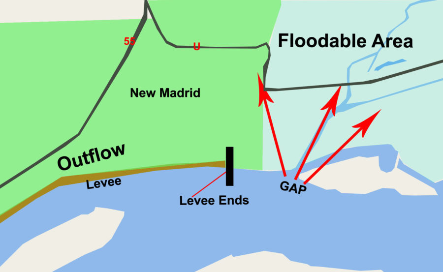
“At the lower portion of the floodway next to New Madrid, Mo., there has been a 1,500-foot ‘gap’ in the levee that allows Mississippi River water to temporarily back up into the lower floodway when water levels in the river get high,” said Jim Garvey, the director of the Center for Fisheries, Aquaculture, and Aquatic Sciences.
{{tncms-asset app=”editorial” id=”7de7a312-e307-11e4-b3eb-cbb4d9944878″}}
Discussions among farmers, the Corps of Engineers and environmentalists will help determine whether the decision to close this gap in the lower floodway to protect farmland outweighs the possible negative effects to the ecosystem.
Advertisement*
The area is also designed to be a catch basin if the river level is high enough to threaten nearby communities, as it did in 2011 for the city of Cairo.
The 135,850-acre floodplain has only been allowed to completely flood three times in the last 75 years. According to the National Wildlife Federation website, one of those times was in 2011 when the Army Cops of Engineers opened the levee, saving the historic Cairo from massive flooding.
The city of Cairo and SIU professors — including Garvey — wrote to Sen. Dick Durbin (D-IL) and President Barack Obama in 2011 to share opposition against building the additional structure and closing the gap.
According to the Missouri Coalition for the Environment, “the New Madrid Floodway portion of the project is estimated to destroy or degrade about 50,000 acres of wetlands.“
Garvey said fish, as well as other ecosystem processes, would be affected by closing the gap in the lower river. These include farm fertilizer abatement, vegetation production, waterfowl and other river processes.
Jim Pogue, a spokesman for the Corps, could not give his opinion either way but said the economic benefits are worth the consideration.
“The biggest concerns are to balance the environmental impacts as well as the social and economic benefits,” he said. “[In] this area of the New Madrid Floodway over 80 percent of the project area is farmland, so preventing a flood on that farmland provides an economic benefit.”
{{tncms-asset app=”editorial” id=”c54ba5be-e307-11e4-b9cf-2b2e7f391e40″}}
Heather Cachola can be reached at [email protected]
Advertisement